Drone Land Survey UK | Aerial Site Data & Mapping
A drone land survey captures spatial data across a site using UAV-mounted sensors, producing orthomosaics, digital terrain models, point clouds, and volumetric calculations for engineering design, planning, and construction. Sky Scan Surveys provides drone land surveys across the UK, delivering georeferenced outputs in OSGB36 or project-specific coordinate systems with documented accuracy.
What Is a Drone Land Survey?
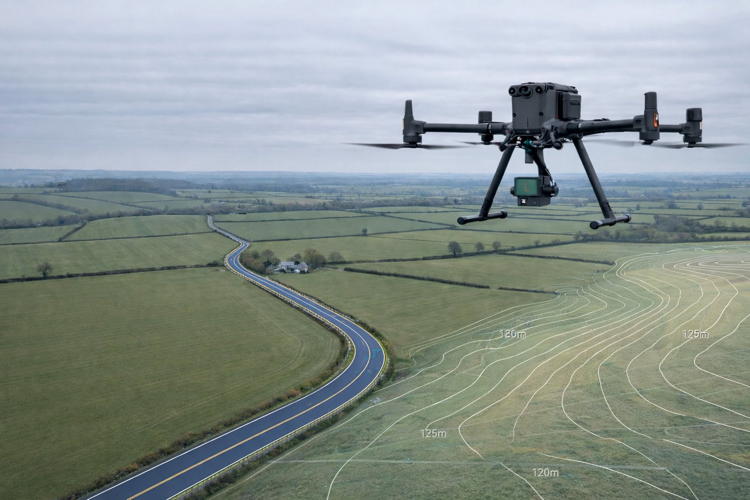
A drone land survey uses a CAA-approved UAV to fly a planned grid over a site, capturing overlapping imagery or LiDAR data that is processed into georeferenced spatial outputs — orthomosaics, surface models, point clouds, contours, and volumetric reports.
This is a method-led service. What you receive depends on the brief: some clients need an orthomosaic and DSM for planning; others need a point cloud and contour set for design; others need repeat volumetric data for earthworks management.
Drone land surveys are not the same as a topographic survey, which is a feature-led drawing produced to design tolerances, typically combining ground-based total station work with aerial data. A drone land survey can feed into topo outputs where required, but it is not a blanket replacement on every project. Where design tolerances or setting out require it, drone data should be integrated with a control network and traditional survey methods.
Benefits of Drone Land Surveys
Speed
a drone covers 10–50 hectares in a single flight session, capturing data that would take a ground crew days on foot
Density
photogrammetry generates millions of points per hectare, far exceeding manual spot-level surveys
Safety
surveyors remain on the ground while the drone accesses slopes, embankments, watercourses, and active construction zones
Cost efficiency
reduced labour, fewer site visits, no scaffolding or access equipment for large or repeat surveys
Minimal disruption
flights are quiet and fast, with no road closures or restricted access zones required
Repeatable
the same flight plan can be re-flown for monitoring, progress tracking, or volumetric comparison at defined intervals
Technology & Accuracy
We use LiDAR for large-area surveys, corridor mapping, and sites with dense vegetation where ground penetration is required. For complex urban sites and buildings, photogrammetry captures high-resolution imagery from multiple angles, providing the visual definition needed for architectural reconstruction. The method is selected at briefing stage based on your site conditions and deliverable requirement.
| Method | Typical Accuracy | Suitable For |
|---|---|---|
| Standard drone mapping | ±20–50mm | Planning, earthworks, site overview |
| RTK/PPK drone survey | ±10–20mm | Most construction applications |
| Drone + control network | ±5–10mm | Detailed design, engineered outputs, stake-out |
Where engineering-grade accuracy is required, we establish a ground control network, process through least squares adjustment, and reference to a defined coordinate system, OSGB36 (National Grid), an arbitrary local grid, or a project CRS where a site-specific origin is required. This produces a defensible surveyor’s accuracy report with verified residuals.
Applications & Use Cases
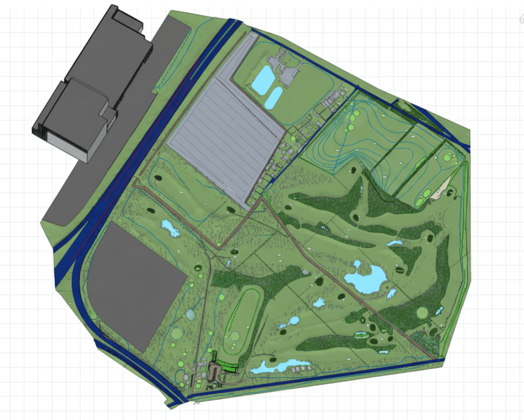
- Land development and planning — level information and orthomosaics for planning submissions and feasibility studies
- Earthworks and cut/fill — volumetric comparison against design surfaces, progress tracking, material reconciliation
- Construction monitoring — repeat surveys to track progress, compare against programme, verify as-built conditions
- Highways and infrastructure — corridor mapping for road design, embankment surveys, drainage analysis
- Agriculture and estates — field mapping, drainage assessment, and land classification over large areas
- Renewable energy — site characterisation for solar and wind farm layouts, access routes, environmental baseline
Project Evidence

Development Site Survey, Wiltshire
Client: A land development company | Sector: Land Development
Context: A developer needed accurate ground level data across a site with mixed terrain and vegetation cover to support earthworks design. Inaccurate ground models mean wrong cut-and-fill calculations — every 100mm of error compounds across the site into hundreds of cubic metres of unexpected material.
- Bare earth digital terrain model
- Contour data at specified intervals
- Classified point cloud with vegetation filtered
- GNSS ground control for positional accuracy
- Bare earth levels captured through vegetation cover
- Data enabled accurate cut-and-fill volume calculations for earthworks design
- Ground model reflected true terrain, not vegetation surface
Method: Drone LiDAR | GNSS ground control | Vegetation filtering and bare earth extraction
The precision and speed of the data delivery were exceptional. It significantly de-risked our design phase."
- Project Lead, Port Authority

Estate Grounds Survey, Buckinghamshire
Client: A landscape architecture practice | Sector: Residential, Landscape
Context: A landscape architect needed ground levels under mature oak canopy for a lake and garden design at a private estate. Photogrammetry can’t penetrate tree cover — the architect would have been designing earthworks based on canopy height, not actual ground level.
- Bare earth terrain model showing true ground levels beneath canopy
- Canopy surface model as separate layer
- Classified point cloud
- True ground surface revealed beneath dense oak canopy
Accurate cut-and-fill calculations possible for lake construction
- Client’s decision to use LiDAR over cheaper photogrammetry validated by data quality
Method: Drone LiDAR | Canopy penetration | Bare earth extraction beneath mature deciduous trees
"Their data-driven approach ensured that our project proceeded with minimal environmental impact."
- EnvironMental Mang Energy Corp. Energy Con paojuer
Our Drone Land Survey Process
Scope and brief
Site area, required outputs (orthomosaic, DTM, point cloud, volumes, contours), accuracy requirements, coordinate system, and delivery format confirmed with the project team.
Flight planning and permissions
Ground control
GCPs are established and surveyed using GNSS to OSGB36 or the agreed project grid, anchoring aerial data to true coordinates. Independent check points are placed for accuracy verification.
Data capture
The drone flies the planned grid at a fixed altitude, capturing overlapping images (75–80% overlap) or LiDAR data. RTK or PPK corrections are applied for positional accuracy.
Processing and QA
Imagery is processed through photogrammetry software to generate the point cloud, orthomosaic, and surface models. Outputs are verified against GCPs and check points. Accuracy is documented.
Delivery
Issued data provided with accuracy statement, coordinate reference, limitations document, and version control via secure link.
Pricing & Service Options
Drone land survey costs depend on site area, accuracy requirements, deliverable scope, and whether a control network needs establishing.
| Survey Area | Price Range |
|---|---|
| Small site — 5ha | £649 – £1,199 |
| Medium site — 20ha | £1,199 – £1,999 |
| Large site — 20ha+ | £1,999 – £3,499+ |
| Engineering-grade survey with accuracy report | Quote required |
| Repeat monitoring programme | Quote required |
| CAD drawings from survey data | From £499 |
All prices exclude VAT. Pricing depends on site area, terrain, accuracy requirements, and deliverable scope. Formal quotes issued once site details and brief are confirmed.
Deliverables & File Formats
| Deliverable | Format | Notes |
|---|---|---|
| Georeferenced orthomosaic | GeoTIFF | True-colour aerial image, map-accurate |
| Digital Surface Model (DSM) | GeoTIFF | Includes vegetation, structures, ground |
| Digital Terrain Model (DTM) | GeoTIFF | Ground surface only (vegetation filtered) |
| Point cloud | LAS / LAZ / E57 | Georeferenced, classified where agreed |
| Contours and breaklines | DWG / DXF | At agreed intervals, OSGB36 or project grid |
| Volumetric reports | PDF + DWG | Cut/fill against reference surface |
| Survey report | Accuracy, methodology, limitations, coordinates |
All deliverables issued in OSGB36 or agreed project coordinate system with version control.
This service does not include issued topographic drawings, setting-out information, or engineering certification unless explicitly scoped as part of a topo survey.
Why Choose Sky Scan Surveys
CAA-authorised and fully insured
All UAV surveys conducted under CAA authorisation with £5m public liability and £1m professional indemnity insurance.
Large-area coverage in one mobilisation
Drone surveys can capture large sites quickly, reducing programme impact compared to ground-only methods.
Accurate georeferenced outputs
Orthomosaics, DTMs, DSMs and contour datasets produced using RTK/PPK workflows.
Ideal for development land and infrastructure
Used for solar farms, earthworks monitoring, development land and corridor mapping.
Safer access to difficult terrain
Drone capture reduces the need to access steep, remote or hazardous areas on foot.
Trusted By


Frequently Asked Questions
What accuracy can a drone land survey achieve?
Standard photogrammetry with GCPs and RTK/PPK achieves ±20–30 mm horizontal and ±30–40 mm vertical. Sub-10 mm is achievable with a dense control network and least squares adjustment. Accuracy depends on GSD, terrain, and site conditions. Every survey includes a documented accuracy statement.
How long does a drone land survey take?
Most sites up to 10 hectares can be flown in a single day. Larger sites may take two days. Processing and QA typically add 3–5 working days. Volumetric reports and contour generation may add 1–2 days depending on complexity.
What is the difference between a drone land survey and a topographic survey?
A drone land survey is method-led — it uses an aerial platform to capture spatial data across a site. A topo survey is output-led — a feature drawing to design tolerances, typically combining ground-based and aerial methods. Drone data can feed into topo outputs, but where full feature detail and design-grade tolerances are required, a dedicated topo survey is the appropriate service.
Can you survey sites with dense vegetation?
Photogrammetry captures the surface as seen from above, so dense tree cover will obscure the ground. For vegetated sites, LiDAR sensors penetrate canopy and return ground-level points for a more accurate terrain model. We advise on the best approach during scoping.
What coordinate system do you deliver in?
Surveys are delivered in OSGB36 (Ordnance Survey National Grid) by default. We can also deliver in project-specific grids, local site grids, or client-defined coordinate systems. The coordinate reference and datum are documented in every deliverable.