LiDAR Surveys — Drone and Terrestrial Laser Scanning
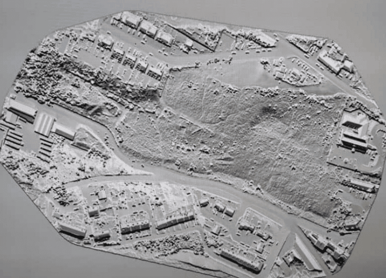
A LiDAR survey uses laser-based sensors to capture dense, accurate 3D point cloud data of a site, structure, or environment. Sky Scan Surveys provides LiDAR surveys across the UK for construction, engineering, and infrastructure projects — delivering classified point clouds, digital terrain models, and derived outputs in OSGB36 or project-specific coordinate systems with documented accuracy statements.
What Are LiDAR Surveys?
LiDAR (Light Detection and Ranging) emits rapid laser pulses that reflect off surfaces and return to the sensor. The time of flight determines distance, and millions of measurements produce a dense 3D point cloud of the scanned environment.
Two primary methods:
- Drone LiDAR — sensor mounted on a UAV, flown over a site to capture terrain, vegetation, and structures from above. Effective for large areas, vegetated sites, and limited ground access.
- Terrestrial LiDAR — ground-based scanner (tripod-mounted or mobile) capturing buildings, structures, and interiors at higher density and shorter range.
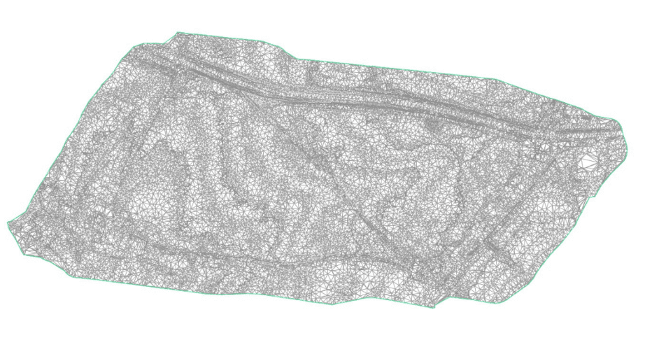
Both produce georeferenced point clouds that are classified and processed into DTM, DSM, contours, CAD linework, and 3D models. For drawing production from survey data, see our CAD services.
LiDAR is a capture method — not an output type. For issued topographic drawings, see Topographic Surveys. For photogrammetry-based aerial capture on open sites, see Drone Surveys.
Benefits of LiDAR Surveys
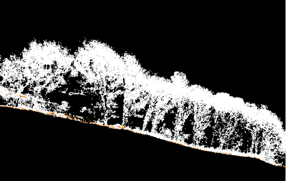
Vegetation penetration
laser pulses pass through canopy and ground cover, returning ground-level data photogrammetry cannot capture
Density
millions of points per second, producing detailed surface models in complex environments
Light-independent
operates in any lighting including overcast, dawn, dusk, and shadow
Speed
large areas captured in hours, reducing site time and programme impact
Accuracy
sub-centimetre with terrestrial LiDAR; ±15–30mm typical for drone LiDAR with control
Non-contact
no physical access to structures required, reducing risk on live sites
Technology & Accuracy
| Drone LiDAR | UAV-mounted sensors capturing 300,000+ points per second. Effective from 1 to 100+ hectares. Best suited to terrain, vegetated sites, and corridor surveys. |
|---|---|
| Terrestrial LiDAR | Tripod-mounted scanners capturing millions of points per position at ranges up to 300m. Best for buildings, structures, facades, and interior spaces. |
| Accuracy ranges (with control network): |
|
Accuracy degrades with range, scan angle, surface reflectivity, and environmental conditions. Sub-10 mm drone LiDAR is achievable in suitable conditions with dense control, least squares adjustment, and careful flight planning. Subject to site conditions and scope.
All surveys include a documented accuracy statement verified against independent check points — not manufacturer specifications.
LiDAR data is not suitable where visual inspection or photographic evidence is the primary requirement — for condition assessment, see drone inspection services. LiDAR is also not a replacement for total station survey where individual point accuracy below ±5 mm is required across the full dataset.
When LiDAR Is the Right Method (and When It Is Not)
Use LiDAR when:
- The site has dense vegetation, tree cover, or ground cover that obscures the surface from aerial photography
- You need a bare-earth terrain model beneath canopy
- The project involves corridor mapping (roads, rail, pipelines, power lines) over long distances
- Interior or exterior structural capture is needed at high point density
- Speed is critical — large areas need capturing in limited site windows
- Light conditions are poor or variable (overcast, dawn, dusk)
- The site is open with clear ground visibility — photogrammetry is faster and cheaper for these conditions
- You need a visual orthomosaic or photographic record — LiDAR produces point clouds, not imagery
- The required deliverable is a 2D topographic drawing to design tolerances — this is a topographic survey output, which may use LiDAR data as an input
- Budget is constrained and photogrammetry would meet the accuracy requirement — discuss with us during scoping
This section exists because choosing the right survey method saves time and money. We will advise on whether LiDAR is appropriate during the scoping stage.
Applications & Use Cases
- Forestry and vegetation mapping — bare-earth DTM beneath canopy for drainage, access, and terrain analysis
- Earthworks and volumetrics — accurate surface models for cut/fill calculations and material reconciliation
- Corridor surveys — roads, rail, pipelines, and power lines mapped efficiently over long distances
- Flood risk and drainage — high-resolution terrain data for flood modelling and surface water routing
- Heritage and conservation — detailed structural capture for listed buildings and conservation areas
- Construction sites — progress monitoring, as-built capture, and earthworks verification on active sites
Project Evidence
Hertfordshire House, Buckinghamshire
Client: A landscape architecture practice | Sector: Residential, Landscape
Context: A landscape architect designing a new lake and garden layout at a private residence needed accurate ground levels beneath a mature oak canopy. The client had initially considered photogrammetry, which is cheaper, but the dense tree cover meant the camera could only capture the top of the canopy — useless for designing ground-level features.
- Bare earth digital terrain model showing true ground levels beneath canopy
- Canopy surface model as separate dataset
- Classified point cloud with ground and vegetation layers separated
- Technical explanation of why LiDAR was the right tool for this site
- Client chose LiDAR over photogrammetry based on our technical recommendation
- Bare earth model enabled accurate lake design with proper cut-and-fill calculations
- Two usable datasets delivered: existing canopy surface and true ground beneath
Method: Drone LiDAR | Canopy penetration through mature deciduous trees | ~20mm accuracy
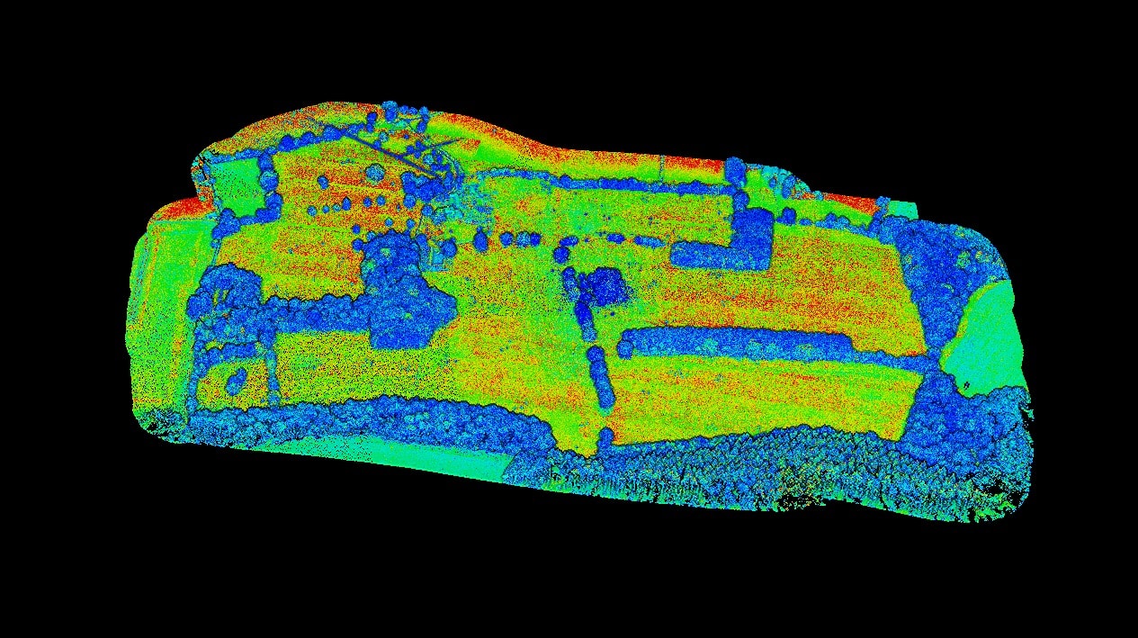
Gompels, Melksham, Wiltshire
Client: A land development company | Sector: Land Development
Context: A developer needed accurate ground level data across a site to support earthworks planning — but the terrain included areas of dense vegetation that obscured the true ground surface. Photogrammetry alone would have modelled the top of the grass and scrub, not the actual ground.
- Bare earth digital terrain model
- Contour data for earthworks design
- Classified point cloud with vegetation filtered
- GNSS ground control for georeferencing accuracy
- 2mm horizontal / 5mm vertical accuracy from ground control points
- Bare earth surface enabled accurate cut-and-fill volume calculations
- Vegetation noise successfully filtered from ground model
Method: Drone LiDAR | TerraSolid processing | GNSS ground control network
Our LiDAR Survey Process
Scope and method selection
Site area, outputs, accuracy, and access reviewed. Drone LiDAR, terrestrial LiDAR, or combined approach agreed based on project needs.
Control network
GCPs established using GNSS to OSGB36 or the agreed project grid, anchoring the point cloud to true coordinates.
Flight / scan planning
Drone: flight plan to required point density with airspace checks and CAA permissions. Terrestrial: scan positions planned for coverage with overlap between stations.
Data capture
Drone LiDAR flown on planned grid with RTK/PPK corrections. Terrestrial scans registered using targets or cloud-to-cloud alignment.
Processing and classification
Point cloud cleaned, classified (ground, vegetation, structures, noise), and registered to control. DTM/DSM, contours, and deliverables generated.
QA and delivery
Checked against independent check points. Accuracy documented. Issued data delivered with accuracy statement, limitations, and coordinate reference.
Pricing & Service Options
LiDAR survey costs depend on method (drone or terrestrial), site area, point density requirements, and deliverable scope.
| Service | Price Range |
|---|---|
| Drone LiDAR survey — small to medium site (up to 10ha) Classified point cloud, DTM, DSM — E57/LAZ output | £1,199 – £1,999 |
| Drone LiDAR survey — large site or corridor (10ha+) Full area coverage, bare-earth model, contours | £1,999 – £3,499 |
| Terrestrial LiDAR — single structure or building ±2–5mm accuracy, registered point cloud, E57/RCP output | £799 – £1,499 |
| Combined drone + terrestrial LiDAR Wide-area terrain + high-density structural capture | £1,999 – £3,999 |
| Point cloud classification and DTM extraction only Processing of existing captured data — no site visit required | From £399 |
Most drone LiDAR surveys for construction or land projects fall in the £1,199–£1,500 range. Terrestrial projects are quoted based on scan positions and site complexity. Sites over 100ha or long infrastructure corridors: Estimate on request
Deliverables & File Formats
| Deliverable | Format | Notes |
|---|---|---|
| Classified point cloud | LAS / LAZ / E57 | Ground, vegetation, structures separated |
| Digital Terrain Model (DTM) | GeoTIFF | Bare-earth surface, vegetation filtered |
| Digital Surface Model (DSM) | GeoTIFF | Full surface including vegetation and structures |
| Contours and breaklines | DWG / DXF | At agreed intervals, OSGB36 or project grid |
| Cross-sections / profiles | DWG / PDF | Along agreed chainages or alignments |
| Volumetric calculations | PDF + DWG | Cut/fill against reference surface |
| Survey report | Accuracy statement, methodology, limitations |
All deliverables issued in OSGB36 or agreed project coordinate system with version control.
This service does not include issued topographic drawings, BIM models, or engineering certification unless explicitly scoped. For Revit model production from point cloud data, see Scan to BIM.
Why Choose Sky Scan Surveys
Drone and terrestrial LiDAR in-house
Drone LiDAR and terrestrial laser scanning delivered by the same team with no subcontracting.
Vegetation penetration and bare-earth data
LiDAR can penetrate tree canopy and dense ground cover to return accurate ground-level terrain data.
Documented survey accuracy
Every survey includes accuracy verification against independent control points.
Method advice before you commission
We advise whether LiDAR, photogrammetry, or combined ground methods are appropriate before committing to survey scope.
CAA-authorised and fully insured
All UAV LiDAR flights conducted under CAA authorisation with £5m public liability and £1m professional indemnity insurance.
Trusted By


Frequently Asked Questions
What is the difference between LiDAR and photogrammetry?
LiDAR uses laser pulses to measure distance directly, producing a point cloud. Photogrammetry uses overlapping photographs processed into 3D models. LiDAR penetrates vegetation and works in any light; photogrammetry produces imagery and is cheaper for open sites. The right method depends on site conditions and deliverables.
How accurate is a drone LiDAR survey?
With GCPs and RTK/PPK, drone LiDAR achieves ±15–30 mm horizontal and ±20–40 mm vertical. Terrestrial LiDAR achieves ±2–5 mm at typical ranges. Accuracy depends on control density, scan geometry, and site conditions. Every survey includes a documented accuracy statement.
Can LiDAR see through vegetation?
LiDAR laser pulses penetrate gaps in tree canopy and ground cover, returning data from the ground surface beneath. This is the primary advantage over photogrammetry for vegetated sites. Dense, low-level scrub may still limit ground returns depending on vegetation density and scan angle.
How long does a LiDAR survey take?
Most sites up to 20 hectares can be flown in a single day. Terrestrial scans depend on scan positions required. Processing and QA typically add 3–5 working days. Classification and DTM extraction may add 1–2 days.
Do I need LiDAR or would photogrammetry be sufficient?
If the site is open with clear ground visibility, photogrammetry is usually faster and cheaper. If the site has vegetation, poor light, or you need bare-earth data beneath canopy, LiDAR is the appropriate method. We advise on the best approach during scoping — there is no charge for this consultation.