Topographic Surveys — CAD Plans, Contours and Site Data
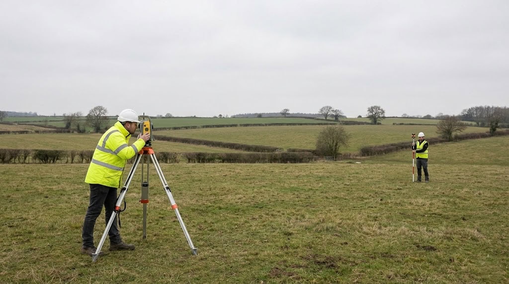
Topographic surveys capture the ground truth of a site — surface levels, features, boundaries, and infrastructure positions — so that engineers and designers can work from accurate, referenced data rather than assumptions. Sky Scan Surveys provides topographic surveys across the UK with documented accuracy statements and coordinate system reference suitable for design coordination and setting out.
Whether you need a topo survey for a pre-construction design package, earthworks verification, or an as-built record, the process starts with understanding what decisions the data needs to support and what tolerances the project actually requires.

What Are Topographic Surveys?
A topographic survey records the physical characteristics of a site — ground levels, building positions, boundaries, trees, drainage runs, kerb lines, overhead cables, and any other features that affect design or construction. The data is processed and delivered in industry-standard formats including DWG, Revit, and point cloud files, referenced to OSGB36 or a site-specific coordinate system with stated accuracy tolerances.
In practice, the scope depends on what the data will be used for. A topo for drainage design needs accurate invert levels and falls. A topo for earthworks needs reliable surface modelling across a wider area. A topo feeding into BIM needs feature coding that translates cleanly into Revit families. We establish the intended use before mobilising, because that determines the method, detail level, and control requirements.
Key deliverables include:
- DWG contour plans and spot height grids
- Feature-coded survey data for CAD and BIM
- Control network reports and coordinate schedules
All outputs are subject to site conditions and independent verification. Data is suitable for setting out within the tolerances defined for each project. For orthomosaic, point cloud, and mapping outputs, see our drone mapping services.
Benefits of Topographic Surveys
The practical advantages come down to confidence in the numbers:
Documented accuracy
every survey is issued with stated tolerances and coordinate reference, so you know exactly what the data can and cannot support
Faster site programmes
capturing ground data in a single mobilisation reduces repeat visits and delays to the design programme
CAD and BIM-ready outputs
deliverables in DWG, Revit, and point cloud formats that plug directly into design workflows without manual conversion
Minimal disruption
surveys are planned around live site operations, particularly on active construction sites where access windows are limited
Verifiable against control
all data is cross-checked against the control network, so discrepancies are identified before the data reaches the design team
Data is issued with version control and is subject to site sign-off procedures where required by the project.
Technology & Equipment
The equipment we use depends on what the site and the project require. There is no single method that suits every topographic survey — the right choice depends on site size, access, accuracy needs, and the deliverable format.
| GPS/GNSS receivers | for open sites where satellite coverage is reliable and ±15–20 mm accuracy is sufficient |
|---|---|
| Total stations | for detail surveys in built-up areas, confined sites, or where higher positional accuracy is needed |
| CAA-approved UAV platforms | for large-area coverage, progress monitoring, or where ground access is restricted. View Drone Surveys → |
| Laser scanning systems | for complex geometry, façades, or heritage structures where point cloud density matters. View LiDAR Surveys → |
| Photogrammetry processing | for orthomosaic production and surface modelling from drone-captured imagery |
In practice, most topographic surveys use a combination of methods — GNSS for control, total station for detail, drone for wider context — with outputs merged in processing. Equipment is calibrated and maintained to manufacturer specifications.
Applications & Use Cases
Topographic surveys are used wherever someone needs reliable, referenced ground data to make a design or construction decision:
- Pre-construction site design — providing the base plan that architects, civil engineers, and planners work from
- Earthworks and cut/fill — surface models used to calculate volumes, verify quantities, and monitor progress against design
- Drainage design — accurate invert levels, falls, and cover depths that drainage engineers require for gravity-fed systems
- Highway and infrastructure corridors — linear surveys for road design, utilities, and transport planning
- As-built verification — confirming that constructed works match design intent within specified tolerances
- BIM model creation — feature-coded survey data structured for import into Revit, ArchiCAD, or other BIM platforms. View Scan to BIM →
Primary clients include construction project managers, design managers, civil engineers, BIM coordinators, and surveying consultants.
Project Evidence
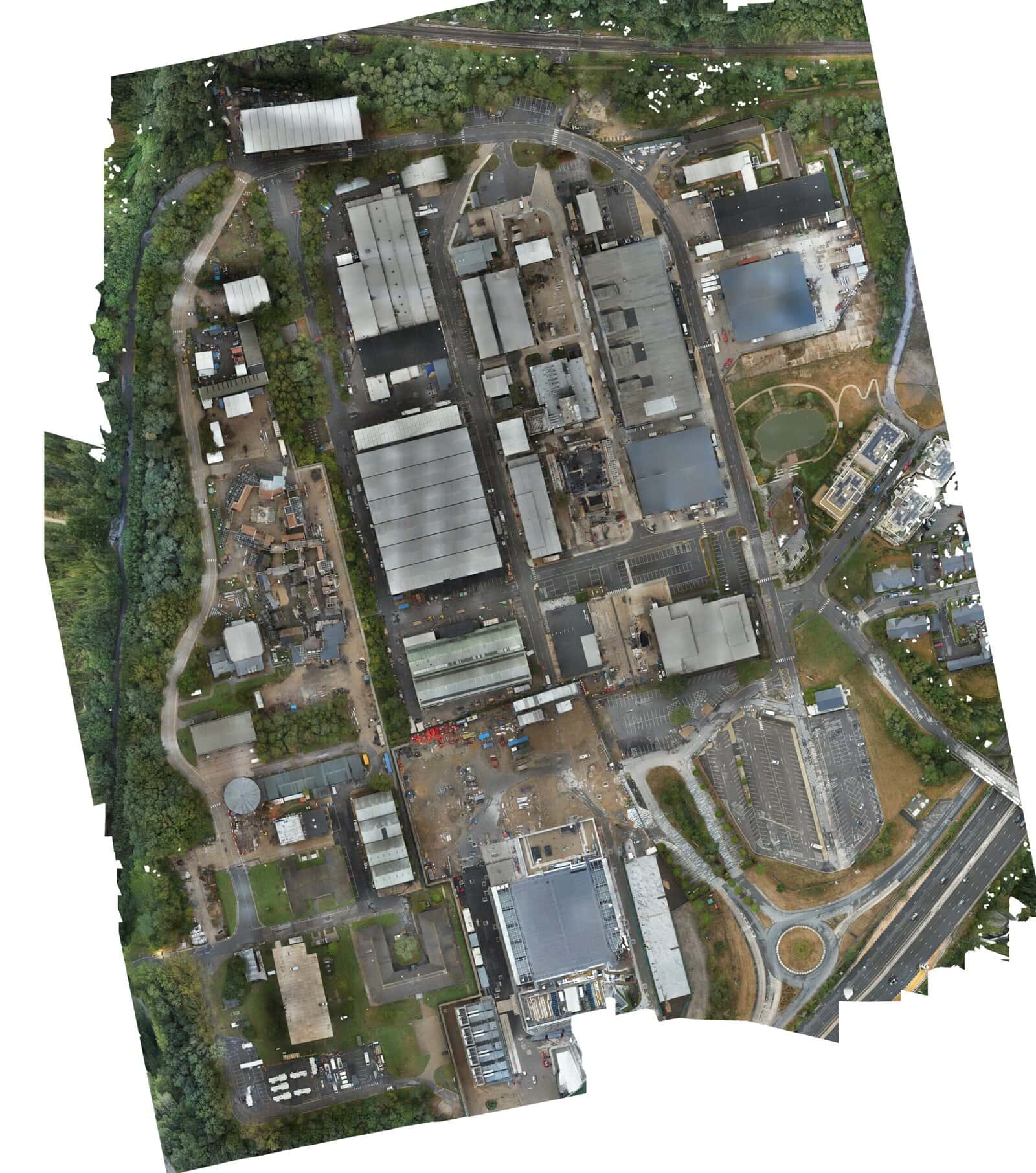
Longcross Studios, Surrey
Client: A major film production facility | Sector: Film, Media
Context: A contractor required a topographic survey supported by a properly designed control network to enable accurate construction setting-out. Aerial survey capture was combined with a high-precision ground control network, allowing the design team to stake out the issued design with confidence using a verified site control framework.
- Unified Civil3D DWG with contours, spot levels, feature codes and boundary data
- Layer naming aligned to the client’s existing CAD standards
- Full site coverage combining aerial and ground methods
- DWG delivered within the agreed programme window
- Set construction planning proceeded without delay
- File imported directly into the client’s CAD environment without rework
Method: Drone survey + total station + GNSS | EDM traverse with ±5mm residuals | Multi-phase capture
The precision and speed of the data delivery were exceptional. It significantly de-risked our design phase."
- Project Lead, Port Authority
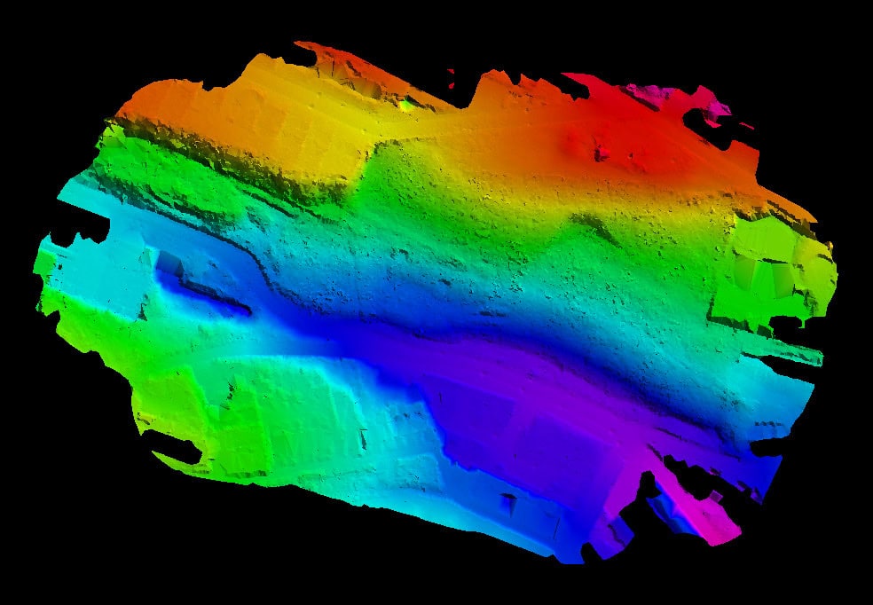
Benn Lane, Longden, Shropshire
Client: A property development company | Sector: Residential Development
Context: A developer needed a full topographic and tree survey for an outline planning application on a greenfield site — but the site was heavily wooded, making conventional ground survey under the canopy impractical. The local planning authority required accurate ground levels beneath mature trees, plus individual tree positions with canopy extents.
- Bare earth surface model including ground levels under all trees
- Individual tree trunk positions and canopy extents as separate CAD layers
- Simplified DWG matching a historic 2001 survey layout for planning continuity
- PDF sheets with 5m spot elevations
- Red and blue ownership boundary lines overlaid
- Bare earth extraction confirmed through dense canopy
- Initial deliverables issued within 5 working days
- Complete iteration (bare earth, canopy layer, simplified layout) finalised within 10 days
Method: Drone LiDAR at 240,000 pulses per second | TerraSolid processing | Rigorous vegetation filtering
"Their data-driven approach ensured that our project proceeded with minimal environmental impact."
- EnvironMental Mang Energy Corp. Energy Con paojuer
Our Topographic Surveys Process
We follow a structured workflow because topographic survey data needs to be defensible — it feeds directly into design, quantities, and setting out. Shortcuts at any stage create problems downstream.
Site requirements review
We confirm accuracy tolerances, coordinate system, deliverable formats, and intended use with the project team. This is where most problems are prevented — agreeing what the data needs to do before we mobilise.
Control establishment
OSGB36 or site-specific control network is established or verified. On sites with an existing control network, we check into it rather than assuming it is correct.
Data capture
Survey-grade equipment deployed by experienced personnel. The method — GPS, total station, laser scanning, or drone — is selected based on site conditions, required accuracy, and access constraints.
Processing
Raw data is processed to client CAD standards with feature coding, layering, and version control applied. Where BIM deliverables are required, data is structured for direct import.
QA verification
Cross-checks are performed against the control network and known site benchmarks. Any discrepancies outside tolerance are investigated and resolved before issue.
Delivery
Issued data is provided with an accuracy statement, limitations document, and coordinate system reference. Deliverables are version-controlled so that revisions are tracked.
Surveys are weather-dependent for optimal data quality, particularly where GPS or drone methods are used. We advise on realistic scheduling at the scoping stage.
Pricing & Service Options
Topographic survey costs depend on site area, required accuracy, deliverable complexity, and mobilisation requirements. Typical projects range from single-visit surveys to multi-phase monitoring programmes.
| Service | Typical Starting From |
|---|---|
| Small site topo survey (up to 0.5 hectare) | £599 |
| Medium site (0.5–2 hectares) | £899 |
| Large or complex site | £1,499 |
| Topo with control network establishment | Quote required |
| As-built or verification survey | £499 |
Pricing is also influenced by:
- Access constraints and working restrictions
- Accuracy tolerance requirements
- Deliverable format — a DWG plan is quicker to produce than a full BIM model
- Control network requirements
- Turnaround time — standard is 5–10 working days; rush turnarounds subject to resource
All pricing includes data processing, QA, and professional reporting. Formal quotes are issued once scope and outputs are confirmed.
Why Choose Sky Scan Surveys
Survey-grade accuracy with control networks
Topographic surveys anchored to GNSS and total station control, referenced to OSGB36 or project grid.
Experienced surveyors
Our team understands the data architects, engineers, and planners require for design and construction.
RICS-aligned survey standards
Surveys delivered following recognised professional survey guidance suitable for planning and engineering use.
CAA-authorised UAV capture where required
Drone capture integrated with ground survey methods and fully insured operations.
DWG, Revit and BIM-ready outputs
Deliverables issued in DWG, DXF, Revit, IFC, LAS and PDF formats suitable for design teams.
We work on live construction sites, controlled environments, and greenfield land. The methodology is adapted to site conditions.
Trusted By


Frequently Asked Questions
What accuracy can topographic surveys achieve?
Accuracy depends on the method, control network quality, and site conditions. Controlled terrestrial surveys typically achieve ±10–15 mm. Drone photogrammetry delivers ±30–50 mm depending on ground control density — ±50 mm is typical without ground control, improving to ±30 mm with a well-distributed control network. Every survey is delivered with a documented accuracy statement.
What deliverable formats are provided?
Standard deliverables include DWG, DXF, Revit (RVT), IFC, LAS, and E57 formats. Where clients have specific CAD standards or layer naming conventions, we process to those requirements. All files include coordinate system metadata and are version-controlled.
How long does a topographic survey take?
Site time depends on area, complexity, and method. A straightforward half-hectare site might take half a day; a complex multi-building site could take several days. Processing and QA typically add 5–10 working days for standard deliverables. Rush turnarounds are available for critical path projects, subject to resource.
What coordinate system is used?
Surveys default to OSGB36 (Ordnance Survey National Grid) unless project-specific systems are required. We can work to site grids, local TBMs, or client-defined control networks. Where we are checking into an existing control network, we verify it independently rather than assuming it is correct. Coordinate system and datum are documented in all deliverables.
Do you provide site visits for scoping?
Yes. For complex projects — particularly those with access restrictions or specific accuracy requirements — a site visit helps assess the right methodology and provide a realistic quote. For simpler sites, remote scoping using site plans and aerial imagery is often sufficient.
Data Accuracy & Limitations
All topographic surveys are delivered with a documented accuracy statement, stated limitations, and coordinate system reference. Data is suitable for design coordination and setting out within defined tolerances — not beyond them. Surveys do not constitute structural assessments or invasive investigations. Underground services, hidden defects, and subsurface conditions are not detected by non-invasive survey methods.