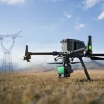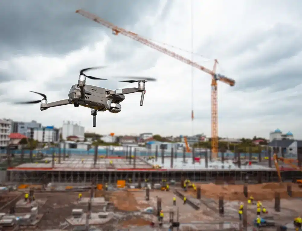
Accurate, up-to-date geospatial data is essential for modern construction, agriculture and urban planning. Traditional land surveys require teams of surveyors, bulky equipment and weeks of fieldwork. Drone mapping uses unmanned aerial vehicles (UAVs) equipped with high-resolution cameras, RTK GNSS and advanced sensors to capture large areas quickly and safely, producing detailed orthomosaic maps, contour lines and 3D models.
In this guide you’ll learn what drone mapping involves, the technology behind it, real‑world applications and how it compares to manual methods. We’ll also share a mini case study demonstrating the benefits of aerial mapping and explain our service packages.
“Switching to drone mapping cut our survey turnaround time from three weeks to three days. The accuracy and detail of the orthomosaic map exceeded our expectations, helping us avoid costly design changes.”
— Emma Bradley, Project Manager, Riverside Developments
What Is Drone Mapping?
Drone mapping, also known as aerial photogrammetry, involves flying UAVs on pre-programmed flight paths to capture overlapping images that software later stitches into maps and models. Key deliverables include:
- Orthomosaic maps – high‑resolution, georeferenced images with uniform scale.
- Digital Elevation Models (DEM) – represent ground surface without structures or vegetation.
- Digital Surface Models (DSM) – include all features, from terrain to buildings and trees.
- 3D point clouds – dense collections of XYZ points capturing complex surfaces.
- Contour lines – lines connecting points of equal elevation.
By analysing thousands of points per second from multiple angles, photogrammetry software reconstructs precise 3D geometry, eliminating the need for manual measurements in hazardous or remote areas.
Technology Used
Delivering survey-grade results requires a combination of cutting-edge hardware and software:
- RTK & PPK GNSS – Real-Time Kinematic (RTK) and Post-Processed Kinematic (PPK) positioning enable centimetre-level accuracy by correcting GPS errors with base station data.
- High-resolution cameras & sensors – Our drones carry 20–45 MP cameras, multispectral sensors for crop health analysis and thermal cameras for detecting heat anomalies.
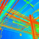
- LiDAR – Light Detection and Ranging uses laser pulses to measure distances, ideal for dense vegetation or low-light conditions where photogrammetry struggles.
- Automated flight planning – Drones fly with consistent altitude, speed and overlap (≥75% front and ≥60% side) to guarantee complete coverage.
- Advanced processing software – We use industry-standard platforms such as Pix4D and Agisoft Metashape to generate accurate orthomosaics, DEMs/DSMs, contour lines and 3D models. Ground control points (GCPs) are deployed to refine accuracy.
Applications: Agriculture, Construction, Urban Planning and Beyond
Drone mapping supports diverse industries and projects. Key applications include:
- Agriculture & Environmental Management
- Crop health assessments (NDVI analysis)
- Irrigation and drainage planning
- Soil erosion monitoring and precision fertilisation
- Construction & Engineering
- Pre-construction land surveys and feasibility studies
- Earthworks and volume calculations (cut/fill analysis)
- Progress tracking and contractor verification
- Urban Planning & Development
- Topographic base maps for planning applications
- Modelling proposed developments within real-world context
- Flood risk and environmental impact assessments
- Mining & Resources
- Resource estimation, stockpile measurement and excavation monitoring
- Safety assessments in hazardous zones
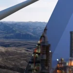
- Utilities & Infrastructure
- Inspection and asset management of power lines, pipelines and railways
- Corridor mapping for route alignment and vegetation management
Mini Case Study: A regional council needed a 12 km corridor mapped for a new cycleway. Our drone survey completed the mapping in two days, delivering an orthomosaic map and DEM with 3 cm accuracy—at half the cost of a traditional survey.
The data was imported into CAD for design and planning, shaving weeks off the project timeline.
Accuracy & Deliverables
With RTK/PPK corrections and ground control points, drone mapping typically achieves 2–5 cm horizontal and vertical accuracy. Deliverables include:
- High‑resolution orthomosaics (2–3 cm pixel size)
- Contour lines at chosen intervals (0.5 m, 1 m, etc.)
- Digital elevation/surface models (DEM/DSM) for cut/fill analysis and hydrological modelling
- 3D point clouds and textured meshes for BIM integration and volume calculations
- CAD-compatible files (.DXF, .DWG, .LAS) for seamless integration with design and GIS workflows
Comparing Drone and Manual Mapping
| Method | Field Time | Accuracy (±) | Safety | Cost Efficiency |
|---|---|---|---|---|
| Manual Survey | Days–weeks | 2–3 cm* | Higher on-site risk | High (labour-intensive) |
| Drone Photogrammetry | Hours–days | 2–5 cm** | Safer; remote operation | Low–Medium |
| Drone with LiDAR | Hours–days | 3–6 cm*** | Safer; remote operation | Medium |
Pricing & Packages
Several factors influence pricing: site size, terrain complexity, required deliverables, ground control points and regulatory requirements. We offer three flexible packages:
- Standard Orthomosaic Package
- High-resolution orthomosaic map
- Basic annotations and measurement tools
- From £450 (<10 hectares)
- Topographic Survey Package
- Orthomosaic + Digital Elevation Model (DEM)
- Contour lines at 0.5 m intervals
- Point cloud (LAS) and DXF deliverables
- From £750
- 3D BIM & LiDAR Package
- High-density point cloud + textured mesh
- LiDAR data (where vegetation penetration is required)
- Integration with BIM software (Revit/ArchiCAD)
- Custom pricing—contact us for a quote
Ready to plan your aerial survey? Use our quote request form to discuss your requirements.
Get a QuoteFAQ
- What is drone mapping?
- Drone mapping uses UAVs to collect overlapping images, which software stitches into orthomosaics, elevation models, and 3D models, replacing manual surveying in many cases.
- How accurate is drone mapping?
- With RTK/PPK positioning and ground control points, we consistently achieve 2–5 cm accuracy, meeting engineering and planning standards.
- How long does it take to complete a survey?
- Most surveys under 10 hectares are flown and processed within 3–5 days. Larger or more complex sites may require additional processing time.
- Is drone mapping cheaper than traditional surveying?
- For large or difficult sites, drone mapping is usually more economical. Smaller, simple sites can sometimes be surveyed manually at comparable costs.
- Do I need special permissions to fly?
- We are fully compliant with CAA regulations, hold Operational Authorisation, and carry comprehensive insurance to ensure legal and safe operations.
Why Choose Us?
- Experienced, Accredited Team – All flights are conducted by CAA-certified pilots and surveyors with years of geospatial expertise.
- Cutting-Edge Technology – Our RTK-enabled drones, LiDAR sensors and advanced processing software deliver survey-grade results.
- Comprehensive Services – From LiDAR Drone Surveying to Scan-to-BIM and Topographic Land Surveys, we provide end-to-end solutions for all surveying needs.
- Proven Results – Clients across construction, agriculture and utilities have reduced project timelines and costs by up to 50%.
- Customer-Centric Approach – We tailor every survey to your goals, provide clear deliverables and maintain open communication throughout.