Measured Building Surveys — Plans, Elevations and Point Cloud
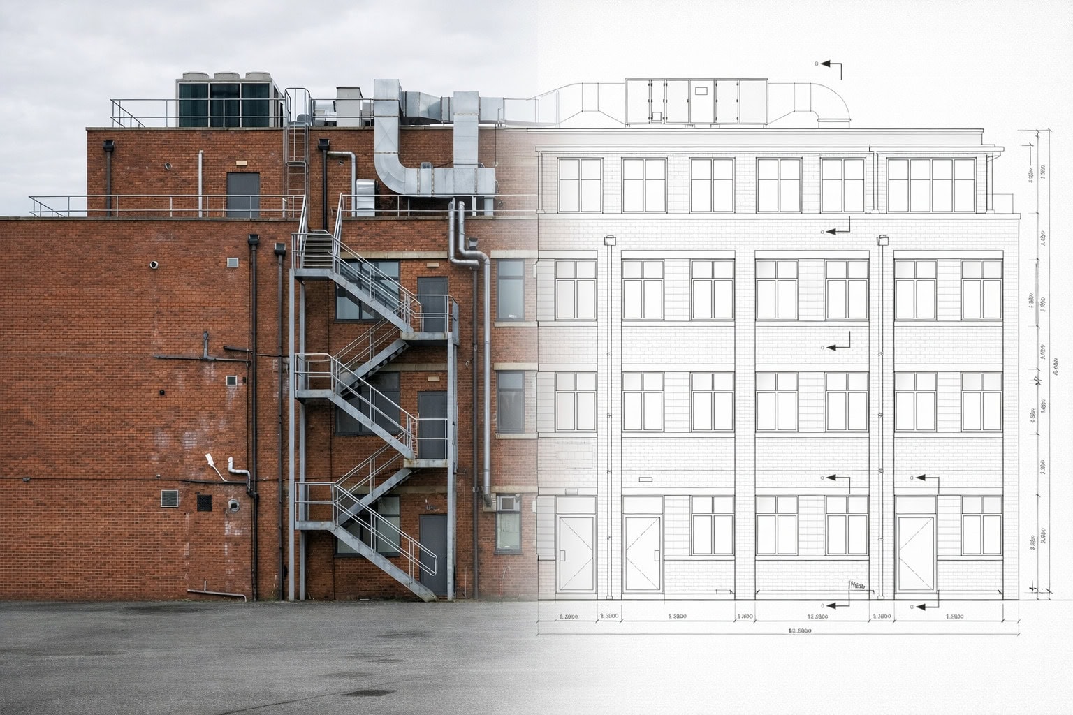
A measured building survey records the existing dimensions, layout, and features of a building to produce accurate floor plans, elevations, cross-sections, and 3D data for design, planning, refurbishment, and compliance. Sky Scan Surveys provides measured building surveys across the UK, combining laser scanning with traditional measurement to deliver verified CAD drawings and point cloud data with documented accuracy and coordinate reference.
What Is a Measured Building Survey?
A measured building survey is a detailed dimensional record of a building as it exists — not as it was designed. It captures the geometry of walls, floors, ceilings, openings, structural elements, and services to produce drawings and data that reflect actual site conditions.
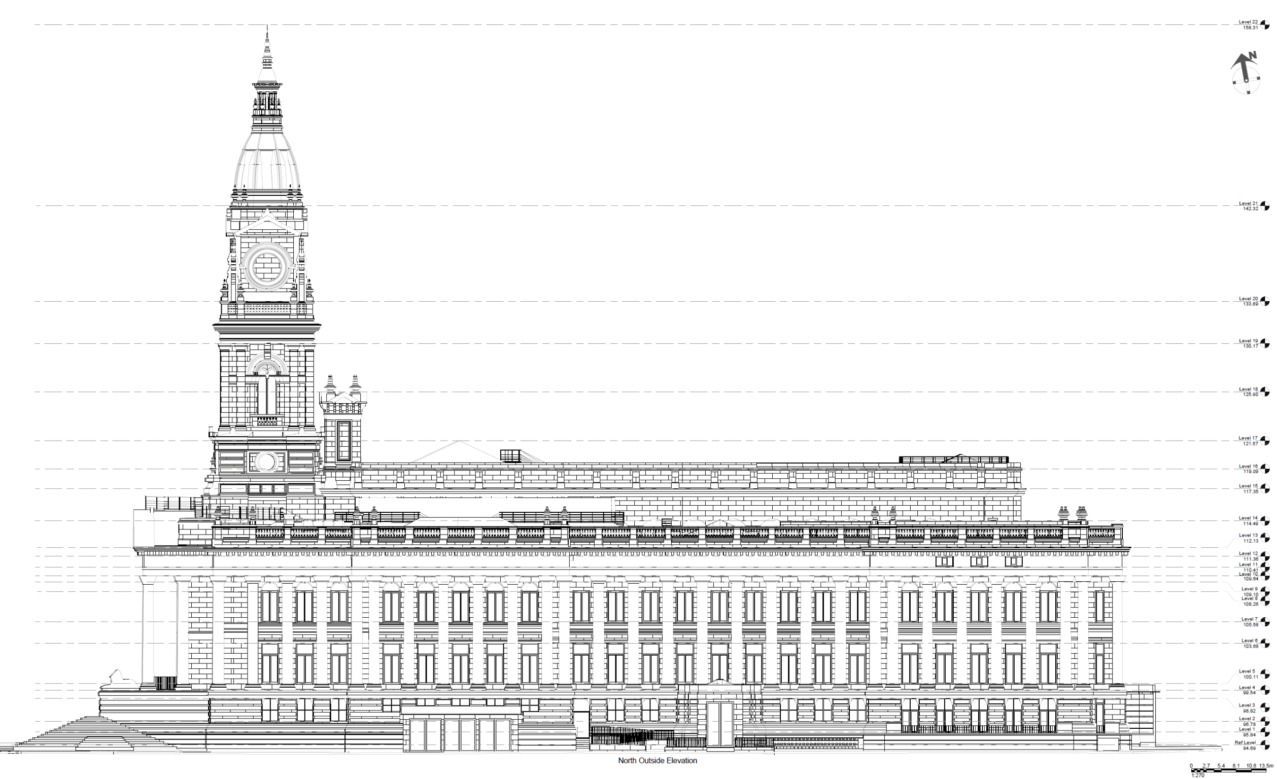
The survey outputs floor plans, elevations, cross-sections, and roof plans in CAD format. Where required, point cloud data and 3D models are included. These outputs form the baseline for architectural design, planning applications, construction coordination, heritage recording, and facilities management.
A measured building survey is the capture and drawing production stage. If you need an intelligent Revit model built from that point cloud — with LOD levels, Revit families, and ISO 19650 workflows — that is a Scan to BIM service. If you have existing survey data that needs drawing up separately, see our CAD Services.
Benefits of Measured Building Surveys
Verified baseline
as-built dimensions and features recorded to stated accuracy, providing a defensible design baseline
Design-ready outputs
floor plans, elevations, and sections delivered in DWG/DXF format to client CAD standards, ready for architects and engineers
Reduced RFIs
accurate existing conditions data minimises requests for information and coordination clashes during design
Access to hard-to-reach areas
laser scanning and drone capture record rooflines, voids, and restricted spaces without scaffolding
Heritage compliance
survey outputs can be prepared to conservation officer requirements for listed building consent
Version control
all issued data is revision-tracked with change logs
Technology & Accuracy
Measured building surveys combine three capture methods depending on building type, access, and output requirements:
| 3D laser scanning | captures the building interior and exterior as a point cloud with millions of measured points. Primary method for complex geometry, multi-storey buildings, and heritage structures. |
|---|---|
| Total station and EDM | provides precise control and targeted measurements for structural grids, floor-to-floor heights, and areas where scanning cannot reach. |
| Drone / UAV capture | records rooflines, parapets, and upper façades that cannot be accessed from ground level. |
Accuracy: Typical measured building surveys achieve ±3–5 mm for internal dimensions from laser scanning, and ±5–10 mm for elevations and cross-sections where access allows clean scan coverage. Accuracy is documented with every survey and verified against independent check measurements.
This service does not include intelligent BIM modelling (Revit families, LOD specification, clash detection). Where BIM models are required from the point cloud, this is delivered through our Scan to BIM service.
Applications & Use Cases
- Refurbishment and fit-out — accurate existing conditions for interior design, space planning, and construction coordination
- Extensions and conversions — baseline data for architects designing additions, change-of-use, or loft conversions
- Heritage and listed buildings — detailed dimensional records for conservation plans, listed building consent, and Historic England requirements
- Planning applications — existing floor plans and elevations required to support planning submissions
- Facilities management — as-built records for estates teams, landlords, and asset managers
- MEP coordination — MEP coordination
Project Evidence
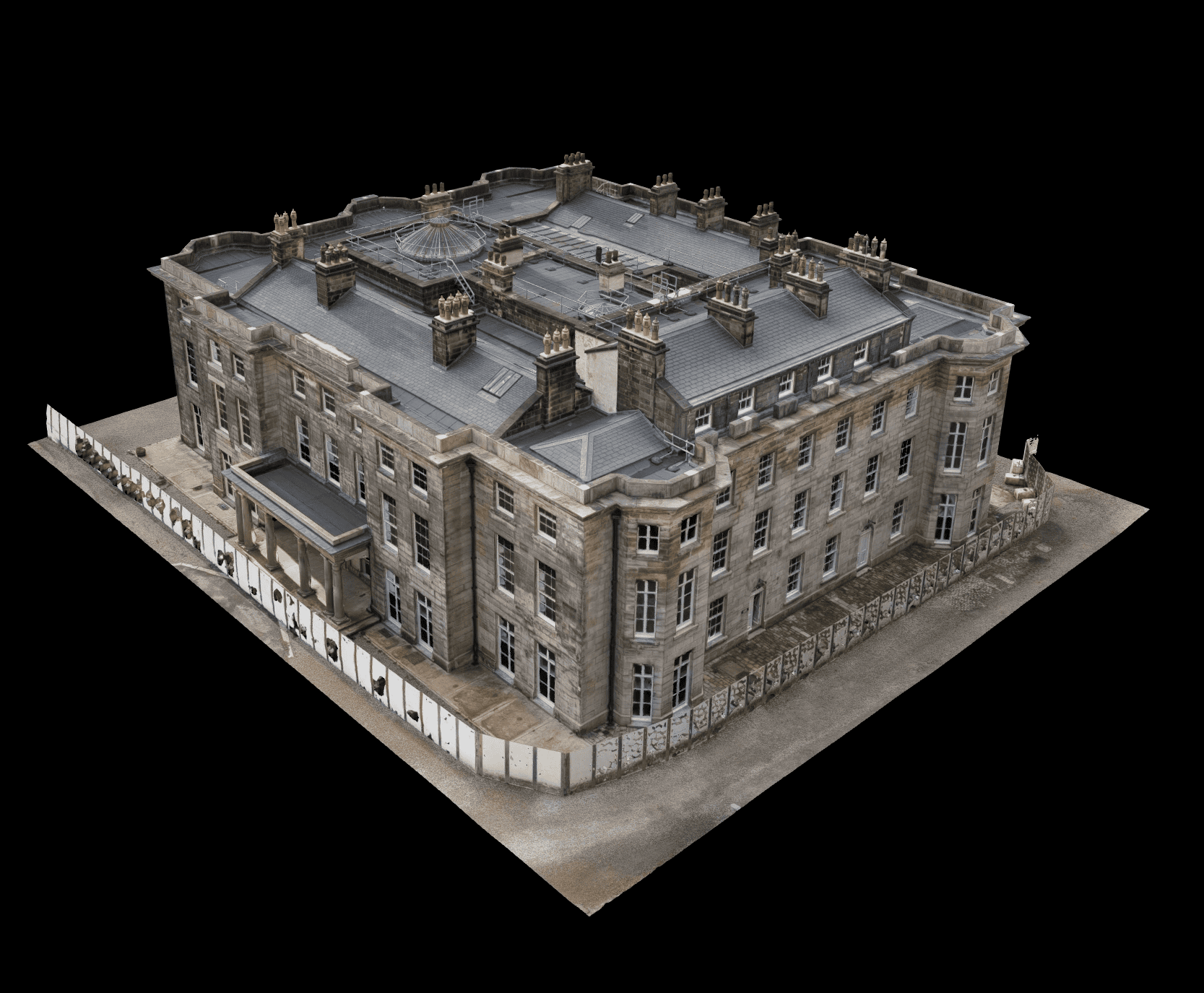
Haigh Hall, Wigan, Greater Manchester
Client: A specialist masonry contractor working with heritage architects | Sector: Heritage, Conservation
Context: Heritage architects and their masonry subcontractor needed a precise measured survey of the roof structure at a Grade II* listed mansion to inform conservation repair works. The building’s listed status and complex roof geometry made conventional measurement impractical — every timber, stone course and roof plane has shifted over centuries.
- 626 million point terrestrial laser scan of the roof structure
- E57, RCS and RCP format point clouds
- Navigable online 3D model for remote team collaboration
- Full accuracy documentation
- Millimetre-accurate data enabled design of conservation-appropriate repair details
- Structural assessment proceeded with confidence in dimensional accuracy
- Entire project team could explore the building remotely via the online viewer
Method: Terrestrial laser scanning | Close-proximity drone photogrammetry | Ultra-high density capture
Accurate and made the job much easier... eager to work together again."
- Project Lead, specialist masonry contractor
Trafford Centre Dome, Manchester
Client: A specialist height access engineering firm | Sector: Commercial
Context: An engineering company needed precise 3D measurements of a complex double-curved dome structure at a major shopping centre to design bespoke rope access equipment. The survey window was restricted to 4am–9am before the centre opened to the public. Any inaccuracy would mean access equipment that doesn’t fit — expensive redesign and programme delay.
- Dense 3D point cloud of the dome surface
- STEP solid model for direct SolidWorks import
- Point cloud exports in .pts, .ptx and .xyz formats
- STEP file accepted by engineering team for access equipment design
- Complex double-curved geometry captured at close proximity (~5m standoff)
- Client returned 6 months later for a second project — confirming output quality
Method: Close-proximity drone photogrammetry | Establishing a control network | Point cloud → STEP conversion
"That model looks amazing."
— Group Engineering Director
Our Measured Building Survey Process
Brief and scope
We confirm the building areas to be surveyed, required outputs (plans, elevations, sections, 3D), accuracy tolerances, CAD standards, and any special requirements (heritage, MEP services, ceiling voids).
Control establishment
A survey control network is set using total station and GNSS, referenced to OSGB36 or the agreed project grid. Control ties all scan positions together and provides verifiable accuracy.
Data capture
Laser scanning captures the building geometry as a point cloud. Traditional measurement with total station and hand tools supplements the scan where access or line-of-sight is limited. Drones capture rooflines and façades where ground access is restricted.
Processing and drawing production
The point cloud is registered, cleaned, and used as the reference to produce floor plans, elevations, and sections in DWG/DXF. Drawings are produced to agreed layer standards and include coordinate reference.
QA and check
Drawn dimensions are checked against the point cloud and independent site measurements. Discrepancies are resolved before issue. An accuracy statement is included with every delivery.
Issue and delivery
Final drawings and data are issued via secure link with a revision number, change log, accuracy statement, and limitations document.
Pricing & Service Options
Measured building survey costs depend on building size, complexity, number of floors, access conditions, and deliverable scope.
| Service | Price Range |
|---|---|
| Commercial building — offices, retail, industrial 3D laser scan, full CAD package, point cloud | £1,199 – £1,999 |
| Large commercial — warehouses, multi-unit, mixed use Full floor plans, elevations, sections, registered point cloud | £1,999 – £2,999 |
| Tower block / high-rise Housing associations, councils — full elevations and communal floor plan | £1,999 – £3,499 |
| Heritage / listed building High-detail fabric recording, conservation officer standard | £1,499 – £2,499 |
| Point cloud + drawings E57/RCP with full CAD drawing set | From £899 |
Pricing follows a per-square-metre model for standard surveys: approximately £2.00–£3.50/m² depending on complexity and detail level. Bespoke quotes are provided for large or complex buildings.
Deliverables & File Formats
| Deliverable | Format | Notes |
|---|---|---|
| Floor plans | DWG / PDF | Included — all levels surveyed |
| Elevations | DWG / PDF | Included — external and internal as required |
| Cross-sections | DWG / PDF | Included — at agreed locations |
| Roof plan | DWG / PDF | Included — from drone or scan data |
| Point cloud | E57 / RCP | Included — registered and coordinate-referenced |
| Survey report | Included — accuracy statement and methodology | |
| Revit BIM model (LOD 200/300) | RVT / IFC | Add-on — see our Scan to BIM service |
| Topographic survey | DWG / PDF | Add-on — external levels, boundaries, site features |
All deliverables are issued in OSGB36 or the agreed project coordinate system with revision control and metadata.
Why Choose Sky Scan Surveys
RICS-aligned survey methodology
RICS-aligned survey methodology and ISO 19650 workflows available where required for projects operating within formal information management frameworks.
Accurate floor plans, elevations and sections
Dimensioned plans issued in DWG, DXF, Revit and PDF formats.
Experienced with complex buildings
Suitable for occupied buildings, commercial sites and heritage structures.
Feeds into CAD and BIM workflows
Survey data integrates directly with CAD drawing and BIM modelling services.
Clear deliverables and turnaround
Survey scope agreed before mobilisation with drawing packages typically delivered within 10–15 working days.
Trusted By


Frequently Asked Questions
How much does a measured building survey cost?
Costs start from £400 for a single-storey residential property. Commercial and multi-storey buildings are typically £1,200+ depending on floor area, number of levels, and required deliverables. Heritage surveys requiring high-detail recording are quoted individually. We provide fixed-price quotes after scoping.
What accuracy do you achieve?
Internal dimensions from laser scanning are typically ±3–5 mm. Elevations and cross-sections achieve ±5–10 mm where access allows clean scan coverage. Accuracy depends on building conditions, access, and scan coverage. Every survey is delivered with a documented accuracy statement.
How long does a measured building survey take?
A single-storey building can typically be surveyed in 3–4 hours on site. Multi-storey or complex buildings may require a full day or multiple visits. Drawing production and QA add 5–10 working days depending on deliverable scope.
What is the difference between a measured building survey and a topographic survey?
A measured building survey records the interior and exterior geometry of a building — floor plans, elevations, sections. A topographic survey records the external land and site features — levels, contours, boundaries, services. They are different services, but are often commissioned together when both the building and surrounding site need surveying.
Can you survey occupied or operational buildings?
Yes. Laser scanning is non-contact and causes minimal disruption to building occupants. We routinely survey occupied offices, schools, hospitals, and retail premises. Access scheduling can be arranged around operational hours.