Precision Topographical Survey Services – Drone-Powered for Speed & Accuracy
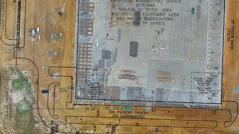
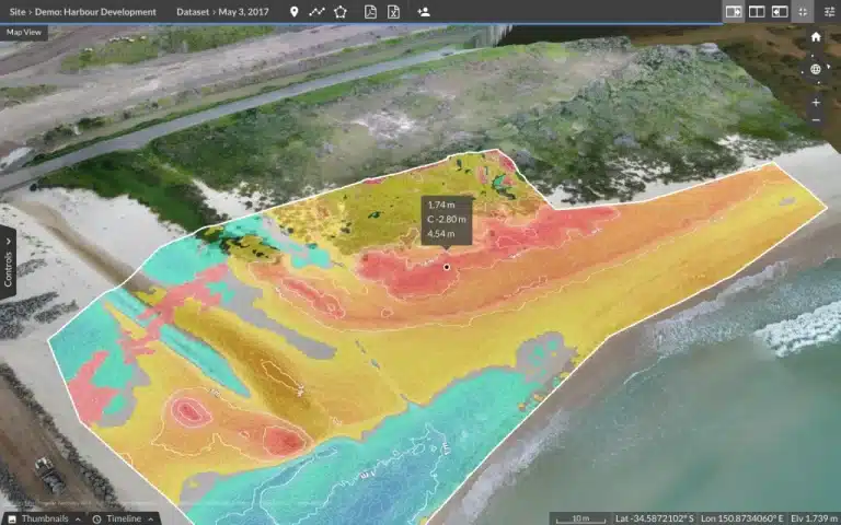
Get CAD ready 2D/3D maps Highly accurate contour lines And precise volume calculations
What Exactly is a Topographic Survey?
A topographical survey, often referred to as a land survey or contour survey, meticulously captures all natural and man-made features on a specific piece of land. This includes everything from subtle changes in elevation (contours), precise boundaries, existing buildings, trees, and other fixed structures. The data is then processed and delivered as highly accurate, CAD-compatible files – essential for architects, engineers, developers, and planners across the UK.
These detailed surveys are crucial for comprehensive site planning, designing new infrastructure, assessing environmental impacts, or managing land use effectively. The precise data we provide is invaluable for civil engineers, construction companies, and property developers to plan projects with confidence, ensuring adherence to regulations, enhancing safety, and significantly minimising unforeseen costs.
How Our Drone Topographical Surveys Work – A Swift, Precise Process
Strategic Flight Planning:
Our fully certified and experienced drone pilots meticulously plan each mission using advanced software, ensuring optimal data capture. RTK (Real-Time Kinematic) or PPK (Post-Processed Kinematic) enabled drones map your site with sub-centimetre GPS accuracy (typically ±2cm), even for expansive areas.
Efficient Data Capture:
We deploy state-of-the-art drones (such as the DJI Matrice 300 RTK) equipped with high-resolution cameras for photogrammetry, or advanced LiDAR (Light Detection and Ranging) sensors. LiDAR is particularly effective for penetrating dense vegetation, allowing us to map the bare earth beneath trees and foliage – crucial for accurate ground modelling.
Precision Data Processing
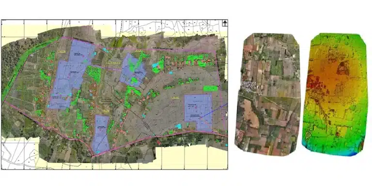
Raw data is imported into industry-leading photogrammetry and mapping software, such as Pix4D or Agisoft Metashape. This software transforms thousands of overlapping images or LiDAR points into highly detailed 3D models, point clouds, digital terrain models (DTMs), and contour maps.
Rapid Deliverables:
Your comprehensive data is delivered in industry-standard, CAD-compatible formats (DWG, DXF, PDF), along with orthomosaic maps and 3D models. We pride ourselves on a swift 48-hour turnaround for most projects, getting you the critical information you need without delay.
Why Choose Drone Topographical Surveys over Traditional Methods?
🚁 Drone Topographical Surveys
- Speed & Efficiency: Typically completed in 1–2 days, with deliverables in 48 hours. Rapid deployment for urgent projects.
- Accuracy: ±2cm RTK/PPK precision for highly accurate, consistent data across the entire site.
- Safety: Operators stay safely on the ground; no need for personnel in hazardous, inaccessible, or remote areas.
- Cost-Effectiveness: From just £499. Often 2–3 times more cost-effective for medium to large sites due to reduced on-site time.
- Data Richness: Produces highly detailed point clouds, orthomosaic maps, 3D models, and comprehensive datasets ideal for BIM.
📏 Traditional Manual Surveys
- Speed & Efficiency: Can take 1–2 weeks for fieldwork alone, with additional time for processing. Slower for large or complex sites.
- Accuracy: Precision can vary; more prone to human error, especially on large or challenging terrain.
- Safety: Requires surveyors to access all parts of the site, including potentially dangerous or difficult terrain.
- Cost-Effectiveness: Higher labour costs and longer project durations typically result in higher overall expenses.
- Data Richness: Primarily provides 2D line drawings and spot heights, with less visual context or detail.
Applications: How Our Topographical Surveys Power Your Project
Our advanced drone topographical survey services provide critical spatial data that is indispensable across a wide range of sectors and project types. We specialise in delivering actionable insights through precise 3D topographic mapping.
Key Areas Where Our Surveys Excel:
- Construction Planning & Development: From initial site analysis to final as-built surveys, our data optimises site layouts, cut-and-fill calculations, drainage designs, and enables accurate project phasing.
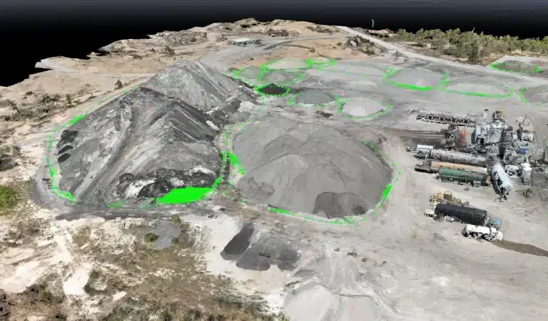
- Land Development & Earthworks: Precisely map contours for efficient grading, earthworks calculations, and volume estimations for quarries, stockpiles, or large-scale landscaping projects.
- Environmental & Flood Risk Assessment: Generate highly accurate Digital Elevation Models (DEMs) to model water flow, assess flood risk, and inform environmental impact studies and mitigation strategies.
- Infrastructure Projects: Support the planning and design of roads, railways, pipelines, and utilities with detailed terrain and existing feature mapping.
- Volume Calculations & Stockpile Management: Accurately measure the volume of aggregates, excavated material, or stockpiles on site, essential for inventory management and progress monitoring.
- Architectural & Engineering Design: Provide foundational, reliable data for architects to design new structures and for engineers to plan foundations, drainage, and utility connections.


Our Streamlined 3-Step Survey Process for Projects Across the UK
Consultation & Project Scope:
We begin with a detailed discussion to understand your exact requirements, site specifics, and project timelines. This allows us to tailor the survey approach to your unique needs.
On-Site Data Acquisition:
Our CAA-certified drone pilots arrive on site, conduct thorough safety checks, and deploy our state-of-the-art RTK/LiDAR drones. Data is captured rapidly, minimising disruption to your operations.
Advanced Data Processing & Delivery:
Back at our office, your data undergoes rigorous processing using cutting-edge software. The final, verified deliverables (CAD files, 3D models, reports) are then securely transmitted to you, typically within 48 hours of data capture.
Need a rush topographical survey? Call
07518511623 for same-week availability across the North West and beyond.
Transparent Topographical Survey pricing
Understanding the cost of a topographical survey is crucial for project budgeting. Our pricing is highly competitive and transparent, offering exceptional value for the precision and speed of our drone-powered services. While every project is unique, here’s a guide to our affordable rates, starting from just £599
Factors Influencing Survey Cost:
- Site Size: Larger areas typically require more flight time and data processing.
- Site Complexity: Dense vegetation, varied terrain, or numerous structures increase complexity (e.g., requiring LiDAR over photogrammetry).
- Required Detail & Deliverables: The level of detail and specific outputs (e.g., just contours vs. full 3D BIM-ready model) will impact cost.
- Location: While we cover the UK, remote locations may incur additional travel expenses.
| Site Type & Size | Estimated Price Range (Excl. VAT) |
|---|---|
| Small Residential Plot (Up to 0.5 hectares) | £599 – £800 |
| Commercial Development Site (0.5 – 5 hectares) | £800 – £2,500 |
| Large-Scale Land Development (5 – 20 hectares) | £2,500 – £6,000 |
| Major Infrastructure/Industrial (20+ hectares) | Custom Quote Required |
Why Choose Sky Scan Surveys for Your Topographical Survey?
When precision, speed, and reliability matter, Sky Scan Surveys is the trusted partner for topographical survey services throughout the UK, from Scotland to London, the North West, and across the UK.
 Expertise, UK-Wide Reach:
When precision, speed, and reliability matter, Sky Scan Surveys is the trusted partner for topographical survey services across the entire UK. From the Highlands of Scotland to the streets of London, our mobile teams serve clients nationwide.
 Unrivalled Accuracy:
We guarantee 2cm relative accuracy for ground features thanks to our RTK-enabled drones and expert processing.

 Expertise, UK-Wide Reach: