Skip to content
  • About
  • Services
    • Scan-to-BIM
    • Drone Roof Inspection
    • Topographic Survey
    • volumetrics, cut and fill
    • CAD Services
    • Drone Land Survey
    • Drone videography & Time Lapse
  • Case Study
    • The Valley Leisure Park
    • Quarry Survey
    • Smithills Halls
    • Manchester City Centre
    • Barrow Bridge Chimney Inspection
  • Pricing
  • Blog
  • Contact Us
Get Started
Picture of Paul Harty

Paul Harty

A drone hovering in the sky amidst clouds, showcasing technology in action.

The Key Differences Between Drones, UAVs, and UAS: What You Need to Know

February 3, 2025 No Comments

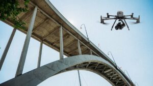
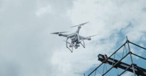
At Sky Scan Surveys, we frequently work with Unmanned Aerial Vehicles (UAVs) to offer innovative surveying and inspection services. However, the terminology surrounding drones UAVs

Read More »

Updated Review of DJI Matrice 4T and DJI Matrice 4E

February 3, 2025 No Comments

The DJI Matrice 4 Series represents a new era in intelligent multi-sensor drones, offering powerful capabilities for a range of enterprise applications. The Matrice 4T

Read More »

How Does a Topographical Survey Work? An Essential Guide to Site Surveys

February 3, 2025 No Comments

A topographical survey is a detailed and accurate representation of a piece of land, capturing all natural and man-made features within the surveyed area. It

Read More »
drone over private property or land

Flying a Drone Over Private Property or Land: What You Need to Know

February 2, 2025 No Comments

Yes, you can fly a drone over private property or land in the UK, but it is subject to specific regulations that ensure safety, privacy,

Read More »

A Guide to DJI Assistant 2: Unlocking the Full Potential of Your Drone

February 2, 2025 No Comments

At Sky Scan Surveys, we know that keeping your drone updated and in peak condition is essential for ensuring top-tier performance. One of the most

Read More »

Drone Laws UK 2025: A Comprehensive Guide

January 18, 2025 No Comments

As drone usage continues to surge, understanding the latest drone laws in the UK is crucial for both recreational and commercial operators. The UK Civil

Read More »
drone used for LiDAR survey

How to Start a Career, as a Drone Surveyor; A Practical Guide for Beginners

July 27, 2024 3 Comments

Hello drone enthusiasts! It’s great to have you on the channel. I’m Paul. Today we’re delving into the world of starting a career in drone

Read More »
drone terrain mapping

The Ultimate Guide to Measured and Topographical Surveys by Sky Scan Surveys

July 22, 2024 No Comments

Sky Scan Surveys provides a range of surveying services, throughout the UK. Our dedicated team conducts each survey with professionalism ensuring we maintain standards for

Read More »

The Complete Guide, to Topographic Surveys; All You Should Know

July 22, 2024 1 Comment

Topographic surveys also referred to as topo surveys play a role for individuals involved in property development, construction and land management. These surveys offer precise

Read More »

Exploring New Opportunities; The Impact of Drone Inspections, in the UK

July 22, 2024 3 Comments

rone inspections driven by vehicles (UAVs) have become a game changer in the UK. These incredible flying devices are revolutionising inspection practices providing benefits that

Read More »
Page1 Page2 Page3 Page4

Get Started Today

We’re here to answer your questions and explore how our services can benefit your project. Don’t hesitate to reach out to us via phone, email, or through our social media channels.

About Us

At Sky Scan Surveys, we pride ourselves on being the best choice for your data needs. When you partner with us, you’ll gain access to a comprehensive suite of services that set us apart. Our precise aerial surveys, meticulous inspections, and high resolution progress monitoring provide you with an unparalleled depth of information, all while sparing you the hassles of traditional data collection methods.

Quick Links

  • Home
  • About Us
  • Topographic Survey
  • Scan-to-BIM
  • Roof Inspections
  • Cut and fill survey

Case Study

  • LiDAR
  • 3D Model/ Revit
  • Topography
  • Cut and Fill
  • Inspection

Contact Info

  • Sky Scan Surveys
  • 07518511623
  • p.harty@skyscansurveys.co.uk
Facebook Linkedin X-twitter Instagram Youtube

Copyright © 2024 | Sky Scan Surveys | Privacy Policy | All Right Reserved.